Category: Tools

Tools used to assist research

Friday Finds: Maryland Historical Magazine

I was recently going through the stacks of materials distributed around my “office” when I came across a document I’d ordered from PERSI—”Proceedings of the Committee of Observation for Elizabeth Township District [Washington County]” from the Maryland Historical Magazine, Volume 13. I had ordered this because copies I had made at the Pennsylvania State Library were difficult to read; I was hoping for a clearer copy.

What I found made me unhappy. The copies I’d made were not from volume 13, number 2; they were from volume 13, number 3. So, here I have a nice stack of reading that doesn’t include the information that I was seeking. My bad for not clearly marking each photocopy with its full source citation!

Maryland Historical Magazine

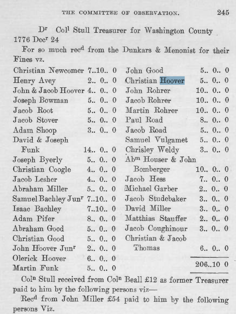
Maryland Historical Magazine, Volume 13, Number 3, page 245 PDF

I went online to see if I could find somewhere I could order copy of the pages from the correct volume. Instead I found a page on the Maryland Historical Society’s website that seemed to imply that they were providing online access to the periodical.

Wow! I logged in and sure enough volumes 1, number 1 through volume 99, number 4 are available online as PDFs through a joint project of the Maryland Historical Society and Maryland State Archives. Volumes 101-104 are available to members of the Maryland Historical Society. The volumes have been indexed, so you can search them.

Online viewing through the PDF viewer I have was not optimal—the text appears jagged and bitmapped. Opening the file in Preview on the Mac (an option in the viewer) was similar. However, downloading the file and viewing in the Adobe PDF viewer solved the problem—crisp, clear text! I search for “Hoover” in the PDF and it skipped to the first notation (see blue highlight).

I’m so glad I decided to clean up a bit and discovered my mistake. It lead to a wonderful online resource!

Added Warrantee Map Indices

I’ve added two new indices to the warrantee maps for Strasburg Township and West Lampeter Township. These indices include the warrantee’s name, the patentee’s name, the tract number (if available), the patent reference (book, volume, page), the survey reference (book, volume, page), and the tract name (if available). The surveys and warrantee maps can be found online at the Pennsylvania State Archives website.

The warrantee township maps are a useful tool in researching your family history and provide an excellent means of visualizing the location of a specific piece of property within the borders of a specific township.

However, when you want to quickly determine if a specific name can be found on the map, it can difficult to do. Frustrated by having to search the map for each name I wanted to locate, I decided to create an index for each township map that I use on a regular basis. Now, I’ve made them available to other researchers. Please see a list of currently available on the Online Genealogy Documents page.

1911 Scottish Census Coming…

The 1911 Scottish Census will be released 5 Apr 2011. More than 4.7 million Scots provided information for this census. Is your ancestor one of them?

What will you be able to find in this census? Details from Scotlands People below:

The records will include the name, address, age, occupation, birthplace and marital status of everyone counted in the 1911 census, as well as details about their children. For the first time, the census data will be presented in full colour rather than black and white.

It will cost 1 credit to view an index entry for the 1911 census. An image will cost 5 credits. Unlike previous censuses, the image spans two pages due to the additional questions that were asked about the fertility of marriage and the profession or occupation. Each page measures 34 cm long by 43 cm high so the images are best viewed on your computer screen or if printed, on size A3 paper.

I’ve used Scotlands People myself to find my Scottish ancestors on my paternal grandfather’s side of the family. It’s a great resouce, easy to use, and well worth the money for a family historian with Scottish ancestry who can’t get over to Edinburgh.

NARA Online Public Access: Have You Tried It?

The National Archives launched Online Public Access (OPA) on Dec. 27th. What is it? It’s a search tool for all their online records and/or information about their records. It will also display the online records. It includes:

  1. Data from the Archive Research Catalog (ARC)
  2. Selected electronic records in the Archive Database (AAD)
  3. Selected electronic records from the Electronic Records Archives (ERA)
  4. Web pages from Archive.gov

For more information, please visit the Narations blog.

Adding Sources in Reunion

Adding source information in Reunion for Mac is a straightforward process. Adding source information efficiently can be a little more tricky. This post shows how I’ve approached the problem.

There are two methods to input source data in Reunion.

Source Fields

When you want to add a source, you can select a source from the “Add Sources” menu on the person or source window. Selecting a source type will open a window with a selection of predetermined fields to fill out.

Adding a book as a source in Reunion

Adding a book as a source in Reunion

You can fill in your source information using these fields, or change the fields by either adding or deleting fields. You can also change the source type from this window. If you enter your information this way, your source will look something like this:

27. Ashby, Bernice M., Shenandoah County, Virginia Marriage Bonds, 1772-1850, Virginia Book Company, Berryville, VA, 1967, 170.

Free-Form Text

Alternatively, you can choose to enter your source information as “free-form” text. This is the solution I’ve chosen, primarily because I want my source citations to conform to accepted standards. Using this method, the same source (as above) would look like:

Adding a free-form text source in Reunion

Adding a free-form text source in Reunion

27. Ashby, Bernice M., Shenandoah County, Virginia Marriage Bonds, 1772-1850 (Virginia Book Company, Berryville, VA, 1967), page 170.

In both of these examples, I’ve included the page number as part of the post. That’s fine if you only need to reference one page in this book. But what if you want to cite multiple pages for for different people or events? Using this method, you’ll wind up adding this book to your source list multiple times. Not very efficient.

Detail Field

Using the Source Citation Detail field

Using the Source Citation Detail field

A good way around this is to make use of the “Detail” field associated with each source citation. In this case, I did not add the page number to the source, but instead added it to the source citation detail field as shown.

When you create a report and include sources, the source will be listed as in the free-form text example, including the page number. But you’ll be able to reuse source #27 for multiple citations with differing page numbers. This will save you time and effort in entering source data.

Much more efficient.

If you need more information on how to use the source citation detail field to capture information, please take a look at the Recording Source Detail in Reunion for Mac video on GenealogyTools.com. While we differ in our use of “Source Fields” vs. “Free-Form Text” and in the data we capture in the “Source Citation Detail” field, this video will give you a step-by-step tutorial on how to use the application.

Evidence! Citation & Analysis for the Family HistorianFor a great book on citations and analysis for family genealogists, please see Evidence! Citation & Analysis for the Family Historian.

Friday Finds: Help Using Reunion for Mac

If you use Reunion for Mac as your genealogy software program, then you should know about a couple of sites that provide very useful instructional videos: MacGenealogist.com and now GenealogyTools.com.

I consider myself pretty knowledgeable about computers and computer software, and I’ve never had any problems using the software, but I’ve picked up a couple of tips about using the software more efficiently.

Here are a couple of articles/videos I found useful:

Friday Finds: FamilySearch Wiki

In looking for information about Roxburghshire, Scotland I came across the FamilySearch Wiki information on Scotland. This site includes information on all the Scottish counties, including information on available records (census, court records, civil registration, etc.), maps, and its parishes. The parish pages will tell you about the records available for that parish, including church and civil records.

I found it quite informative—especially the list of parishes in each county and the parish information. The pages also point to another site I’ve used successfully—Scotlands People (the Scottish Records Office)—to find census, birth, marriage and death records.

It also points to a site that has UK census records online—for free! I found my ancestor William Bonnington in the old town of Galashiels in Selkirkshire in the 1841 census. It doesn’t give you an image to view like Scotlands People does, but it will show you the household and its associated information. You can click to view the previous or next household if you want to see more about the neighbors. The data is not 100% for every county for every census, but there is a page to see the database stats for each.

Friday Finds: Scottish Maps

One of the joys of browsing other genealogy blogs—besides getting ideas on how to organize information, which always intrigues the designer in me—is finding new goodies to help my research. So, hat’s off to Kathleen Moore for finding and posting two helpful maps of Scotland in her blog “The Misadventures of a Genealogist”.

The first is a map showing the locations of the various Scottish clans. The only surname I recognize from my family is Buchanan, shown just to the north of the Highland border line, northwest of Glasgow. My Buchanans seemed to have been miners and were located in Shotts in Lanarkshire.

Scottish Clan map

Scottish Clan map (src: Geneawiki)

The second map shows the administrative subdivisions in Scotland. The majority of my Scottish ancestors lived in Lothian (East, West & Mid), Lanarkshire, and parts of the Scottish Borders.

Scottish Administrative Subdivisions

Scottish Administrative Subdivisions (src: Wikipedia)

Making a Deed Map from Old Metes and Bounds

As you may know I’ve been working with land records a lot recently. I started with the surveys available for Lancaster County land warrants and patents, grouping them by township and name. I’ve also been going through Hoover family deeds for Lancaster County and assigning them to the appropriate Hoover family. My goal is to tie the deeds not only to a particular Hoover family, but also to a particular tract of land back to the original patentee. Sometimes, the information is readily available in the deed itself; sometimes it requires some backtracking through deeds.

As part of the process, I’ve been trying to create deed maps for deeds where I have questions—especially where the land is being divided amongst the heirs. I like to think that I’m a smart person, but I had some problems figuring it all out. Since I didn’t really find an answer online, I thought I’d share what I learned.

Data Entry form for Metes and Bounds

Data Entry form for Metes and Bounds

I downloaded a Mac application called Metes and Bounds by Sandy Knoll Software. It’s a neat program with some cool features. Using the application to map a deed is fairly simple. You enter direction (north/south), degrees, bearing (east/west), and distance. Doesn’t seem complicated, does it?

Except I kept coming across metes and bounds descriptions like this:

“…Beginning at a chestnut tree, thence by the other Land of said Henry Hoober West by South fifty six perches to a post, then South South East fourteen perches to a post, thence by land of Ulrich Hoober East South East fourteen perches to a post and thence South East eight perches to a white oak, thence by Land of George Feite North twelve degrees East one hundred six perches to a Hickory and South eighty four degrees seventy two perches to a post, thence North twenty six perches and an half to a Chestnut Tree and North North West thirty perches to a Black Oak by Beaver Creek and thence by other Land of said Henry Hoober South South West forty perches to the Place of Beginning…”

What do I do with that? Some if it looks usable. But how was I supposed to enter “South South East?” None of the available options came close.

So, I scoured the web looking for help. I sort of found what I was looking for. The article I found involved converting those directions into degrees using this “Box the Compass” chart.

Okay. Seems simple. I took the degrees from the “middle”column and entered them in the degrees field of the data entry form, thinking I had my solution. Nope. My maps looked like scribbles.

Apparently, I missed a step in the conversion process. In order to get a bearing that would work in the application, I needed to take the degrees from the chart and convert it.

Convert Azimuth to Bearing

Convert Azimuth to Bearing

If you click on the down arrow beside the degrees field, one of the options is “Convert Azimuth to Bearing.” If you enter the degrees from the chart there, it will convert it to a bearing that the program can use to recreate the equivalent of “East by North” or “East South East.”

Once I started changing the degrees I’d entered using this method, my maps started looking more like maps and when the deed said “to the place of Beginning” my lines actually met up!

So, if you would like to make plat maps from old deeds for your family research and you use Metes and Bounds, this is how to convert the “old directions” to a useable bearing using degrees.