Wordless Wednesday: Conestoga Township Warrantee Map

A Pennsylvania Dutch Genealogy
the genealogy & family research site of Kris Hocker
If you’ve read my blog, you’ll know that I use land records—a lot! I’ve mentioned warrants, patents and deeds in a number of posts. They’re some of my favorite record groups. And best of all, depending on where your ancestor lived, the records may be available online for free.
This blog post is going to explain how to use the land records available online at the PA State Archives. These records are organized by record and then either by county or volume and surname. They have been scanned and placed online as PDFs by page. The records include:
I’m going to focus on the records in bold.
To understand how to use these records, it’s important to understand how the process worked in Colonial Pennsylvania.1 Technically, William Penn owned all of the land in Pennsylvania. A settler would apply to the land office for land. Before 1687, these applications were typically oral and not recorded. After 1687, they were recorded in the minute books of the Commissioners of Property. The minutes can be found in Pennsylvania Archives, Second Series, Volume 19 and Third Series, Volume 1.
After the application, a warrant was issued to authorize a survey of the land. The warrants I’ve seen specify the name of the warrantee, the location of the desired property (sometimes rather generally), the amount of land, the quit-rent—and sometimes the date from which the rent commences—and the price per acre. The issuance of a warrant, however, does not mean that the applicant actually owned the property.
When a warrant was issued, orders were sent to the surveyor to survey the property and draw a map of the courses and bounds, the acreage, and the neighbors. After a survey was done, the applicant would have to pay for the land and provide evidence of their improvements to the property. In viewing the survey books, there are sometimes multiple surveys of a tract of land. Sometimes the original applicant failed to follow through, sometimes they sold their “rights” to someone else prior to the patent, or sometimes subsequent owners required a re-survey.
Once the survey was complete and the land paid for, a warrant of return was sent to the surveyor general, who in turn sent the survey to the secretary’s office so that a patent could be issued. The patent is the document that transferred ownership of the property to the settler.
So, warrants, patents and surveys deal with transfers of land between the Pennsylvania land office and the settler. Records of land transferred between individuals will be found—if recorded—at the Recorder of Deeds for the appropriate county. This may not be the same as the modern county. For more information on the historical transformation of the counties, take a look at the Genealogical Map of the Counties.

Ulrich Hoober, Patent Book A11:408
If you know that your ancestor received a patent for their property, you can begin with the Patent Indexes. How would I know that, you ask. Often, deeds—sometimes several transactions removed from the patent—will reference the original patent for the property. You may have seen something like:
It being the same tract of land which the late Proprietaries of Pennsylvania by their Patent dated the twenty eighth day of September A. Dom. 1744 and recorded at the Rolls Office at Philadelphia in Patent Book A vol 11 page 408 &c did grant & confirm to Ulrich Hoover his heirs and assigns forever…2
If you haven’t seen a reference like this, but want to know if your ancestor was an early landholder, the Patent Indexes are still a good place to start. The Patent Indexes will not only provide the patent book, volume and page number for a patent, but will also identify the name of the original warrantee and the date of the warrant. This will make it possible to locate the warrant and survey if your ancestor was not the original warrantee.
If you find your ancestor, make note of the series, volume, page and date of the patent. You’ll need this information if you want to order the patent from the Archives. You should also note the name of the original warrantee, the date of warrrant and the county. This will be necessary for the next step.
In the image above, we have a patent for Woolrick Hoober, dated 20 Sep 1744, with 226 acres in Patent Book A11, page 408. We can also see that he is listed as the original warrantee for a warrant dated 19 Sep 1744 in Lancaster County.

Woolerick Hoober, Warrant H338, Lancaster County
Now that you have the name of the warrantee, warrant date and county, you can look-up the warrant and survey information in the Warrant Registers. These registers cover approximately 70% of all land in Pennsylvania for 1733—1957. If the warrant date is 1733 or later, follow these instructions.
Woolrick Hoober’s listing tells us that he was issued a warrant (#338) to accept a survey of 226 acres in Conestoga Township, dated 19 Sep 1744. The patent was issued 19 Sep 1744 on 226 acres. The patent is listed in Book A11, page 408 and the survey is in book D88, page 127.
If the warrant date was before 1733, you’ll need to check the Old Rights Index for Bucks and Chester counties or the Philadelphia Old Rights Register.

Woolrick Hoober, Survey Book D88:127
With the location of the survey from the Warrantee register, the next step is a piece of cake.
Ulrich’s survey shows that John Line, Jacob Hoober, and John DeHoof were his neighbors at the time of the survey—20 Oct 1728.
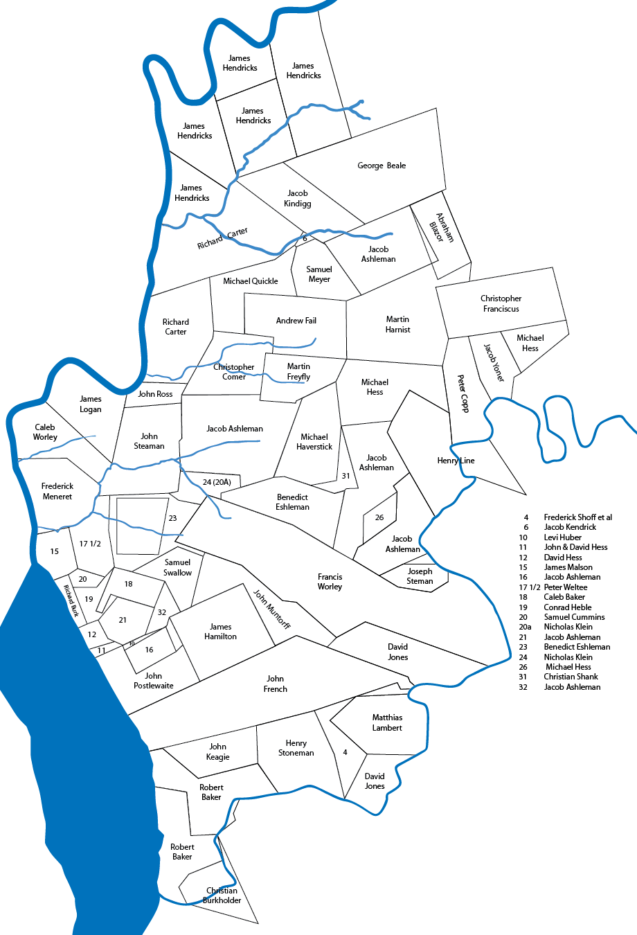
Maps for some of the townships were drawn up showing all of the original landholders—those who received the property directly from the Proprietors or the Commonwealth—within the context of the present-day townships. Unfortunately, not every township was mapped.

Pequea Warrantee Township Map
To find a map of the township were your ancestor held property, you need to know the relationship between the historical township and the modern township. For instance, Ulrich Hoober’s tract was in Conestoga township when he received the patent in 1744. Two modern townships—Conestoga and Pequea—make up the historical 1729 township.3 You can see Ulrich Hoober’s property in the context of the township’s other properties in the Pequea Warrantee Township map.
Don’t forget, using this information you can order a copy of the land warrant or patent from the Pennsylvania State Archives. If you know the reference—warrant number, warrantee and county of warrant for warrants or patentee, patent date, book, volume and page number for patents—you can order an uncertified copy fairly inexpensively. If you don’t have that information, you can also order a search by the staff archivist. That, of course, will cost you more. Warrantee township maps are also available for sale.
If you can visit the state archives in Harrisburg, you can use the information you found through the online records to locate the documents on microfilm, saving time looking up the references so you can research other records.
That’s a fairly quick explanation of warrants, patents and surveys at the Pennsylvania State Archives website. These instructions should work for most properties. However, there will be exceptions (aren’t there always?). If you have questions, leave a comment or drop me a line. I’d be glad to help however I can.
Note: modified to include new PHMC screenshot.
NEW: Conestoga Township Warrantee Map index in the Online Documents section!
“Pennsylvania County Marriages, 1885-1950” @FamilySearch.org includes images from the marriage dockets from local courthouses. I’ve found some of my relatives, but not all of the records that I already have from the actual books.
The earliest established settlement in Lancaster County occurred in the fall of 1710 while it was still a part of Chester County. A small group of Mennonites made a deal for land with William Penn. He wrote to the Ambassador in the Netherlands in April 1710 telling him of a party coming to Holland in order to go to Pennsylvania.1
We know their names because this group wrote a letter to the Mennonite leaders in Amsterdam dated 27 June 1710 to thank them for their assistance. They were on their way to Pennsylvania, expecting to sail within a few days to Gravesend, England and from there to America.2 The letter was signed by Martin Oberholtzer, Martin Kendig, Christian Herr, Jacob Müller, Martin Meili, and Hans Herr. Their ship, the Maria Hope, arrived in Philadelphia 23 September 1710.
On 8 October 1710 land warrants were issued to Martin Kundig, Martin Meily, Christian Herr, John Herr, Wendell Bowman, John Bundely, Christopher Franciscus, and Jacob Müller.3 Martin Oberholtzer, an original member of the group, did not participate in the land purchase. Surveyor James Taylor was ordered on 10 October 1710 to survey 10,000 acres for the Colony of “Swissers lately arrived in this Province” at Pequea.4 The area they settled includes present day Willow Street, stretching across West Lampeter Township over Pequea Creek and into Strasburg Township and Strasburg village. The purchase was divided amongst these men on 12 April 1711.5

Original Pequea Settlement Land Warrants
About 1715 or 1716, Martin Kendig returned to Europe to convince other Mennonite families to come to Pennsylvania. On 22 November 1717, Martin Kendig & Co. (John Herr) were issued a warrant for 5,000 acres in Chester County (now part of Lancaster County).6 I found the following in the Copied Survey Books:
Pensilvania SS
(Seal) By the Commissioners of Property
At the Requests of Martin Kundigg and Hans Heer both of the Township of Strasburg in this Province that we would Grant them to take up Several Tracts among the late Surveys made on Conestoga and Paque Creek the quantity of ffive Thousand Acres of Land for which they agree to pay to the Proprietrs use ffive hundred pounds Mony of the said Province for the whole or in Proportion should there be Returnd upon the Survey thereof more or less and the Yearly quitrent of one Shilling Sterling for every hundred Acres These are to Authorize and Require thee to Survey or cause to be Survey’d unto the said Martin Kundigg and Hans Herr among the said late surveys according to the Method of Townships appointed in several Regular Tracts the quantity of ffive Thousand Acres of Land that hath not been already Survey’d nor appropriated nor is Seated by ye Indians and make Returns thereof into the Secretarys Office which surveys by thee mad by Vertue hereof in case the said Martin & Hans fulfill the above agreement by paying down the said sum of Mony upon the Returns of the said surveyes shall be Valid otherwise the same is to be Void as if it had never been made of this Warrant ever granted Given under our hands and Seal of the Province at Philada the 22d day of 9br [November] Anno Din 1717Richard Hill
Isaac Norris
James Logan
To Jacob Taylor Surveyr General
In Testimony that the above is a copy of the original remaining on file in the Department of Internal Affairs of Pennsylvania made conformably to an Act of Assembly approved the 16th day of February 1833, I have hereunto set my Hand and caused the Seal of said Department to be affixed at Harrisburg, this Thirtieth day of March 1909
Henry Hauck
Secretary of Internal Affairs7
The Chester County Old Rights Index notes a number of surveys associated with this warrant. They include:
I don’t know if these add up to 5,000 acres—some of the surveys are duplicates or overlap previous surveys; some include land from separate warrants. But they should be a good representation of the Kendig & Herr 5,000 acre warrant as divided amongst Lancaster settlers after November 1717.
If you’re searching for information on early immigrant ancestors who settled in Lancaster County, you can find land information at the website of the Pennsylvania State Archives. The warrant registers for Lancaster County will list warrants issued starting in 1733. For earlier records, try the Old Rights Registers for Philadelphia, Bucks and Chester counties—Chester is the best place to start for pre-1729 Lancaster records.
If you know who the land was patented to, but not who it was warranted to, try the Patent Indexes. That will give you the warrantee and warrant date. The warrantee township maps are also a good place to look if you’d like to see where your ancestor’s property was located. The files are listed by the modern townships, so you’ll need to know the relationship between the historical townships and the modern ones. If you don’t, try this map at the Lancaster Historical Society’s website.
Lancaster deeds for this period are also available online. You can read more on how to use the online reader and where to find images from the Grantors index. Unfortunately, the . Deeds and deed indexes are available through the Lancaster County Recorder of Deeds and FamilySearch.Grantees indexes are not online, so you may have to get creative to find what you’re looking for
Have you found a Lancaster County ancestor in online records? What did you learn about them?
I found Elizabeth Shown Mills’ Historic Pathways thanks to a post by Randy Seaver on Google+. Browsing her articles, I chose one almost randomly—“The Search for Margaret Ball”—and started reading. I was instantly engrossed. The search for Margaret Ball’s origins was quite the mystery, the research enlightening. Of course, I had to go on and read “In Search of ‘Mr. Ball’: An Exercise in Finding Fathers.” It, too, was eye-opening.
That’s the kind of genealogy I want to do—the kind I hope I am capable of. If you get a chance, stop by her website and read some of her articles. You won’t be disappointed.
I’ve been trying to get the Trinity Lutheran Church Records, volumes 1-4, through ILL for some time now with mixed results. So, imagine how pleased I was to find some of the records online in the Internet Archive. The Pennsylvania-German Society published their Proceedings and Addresses in the 1890s. Several volumes included records from Trinity Lutheran Church.
These are just the volumes containing the Trinity Lutheran records. Other volumes that have been put online include records from St. Michael’s in Philadelphia and New Goshenhoppen in Upper Hanover, Montgomery County. View more examples of publications from the Pennsylvania-German Society to see if they might have records you’ve been looking for.
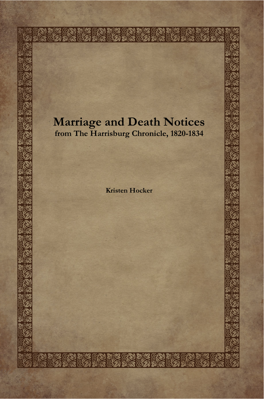

Marriage and Death Notices from the Harrisburg Chronicle, 1820-1834
I’ve been working on this book on and off since my previous book was published. The editing, formatting and indexing took the longest. Then in the excitement of research successes, I forgot about it. After recently finding it again, I polished it up and decided to give self-publishing a try. And now—after some trials and tribulations in getting it ready for print—it’s available for sale!
This book includes 175+ pages of marriage and death announcements from a Harrisburg, Pennsylvania newspaper published in the 1820s. Because newspapers of the time commonly shared information, there are announcements from multiple Pennsylvania counties as well as other states.
During this period marriages and deaths were not recorded by the state, so church records, newspaper announcements, and family records may provide the only documentation of these pivotal events in our ancestors’ lives.
“Monday, 5 August 1822, Vol. X—No. 10
Married—At Huntingdon Pa. on the 11th July last, John Williamson, Esq. attorney at law, of the borough of Indiana, Pa. to Miss Eliza Steel, daughter of Samuel Steel, Esq. of Huntingdon, Pa.”
The book is available in both paperback and downloadable formats. It includes an every name index.

Pages: 236
Binding: Perfect-bound Paperback
Interior Ink: Black & white
Dimensions (inches): 6.0 wide × 9.0 tall
Print: $21.99
Download: $12.99
Available for purchase on Lulu and Amazon.
This book is a follow-up and continuation of my previous book Marriage and Death Notices in Harrisburg Area Newspapers, 1835-1845.
I‘m accustomed to visiting the websites of state and county archives to learn more about their holdings to determine if I should plan a visit or request information by mail. Sometimes you can find quite a bit more. Such is the case with the York County Archives (Pennsylvania).
I’ve been pondering additional research on Christian Hoover of Heidelberg Township. His will names his brothers Ulrich, Jacob and Henry and his sister Ann Keny, but doesn’t provide any additional information. The will specifically leaves money for the surviving heirs of his brothers and two of his sister’s sons John and Henry, but again does not provide any other clues, no other names or locations.
Wondering what estate information was available for research and where I could write to get it, I did a search for York County estate files and wound up at the York County Archives website. The site provides a list of available records and additional information on each records group. It also provides access to indices for many of the records groups. You can search by surname and the site will provide a link to an index in PDF format for that name.
Although the Estate Files (1749-1958) were not indexed, I emailed the archives and they very quickly got back to me with a list of available records from Christian’s estate file AND suggested some additional files for a Ulrich Hoover that might be relevant. I ordered the files, paying by credit card online, and received them as PDF files the NEXT morning via email. Since then I’ve also ordered several deed files and experienced the same friendly, efficient and fast turnaround.
Talk about customer service!
If you know specifically what document you’re looking for and can’t get to York County yourself, this is a fantastic alternative to hiring a researcher or ordering films through the FHL. I know I’ll probably be ordering more records in the near future!
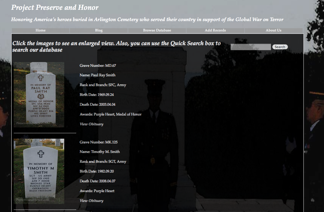
A teenager named Ricky Gilleland has created a digitized record of the graves of Afghanistan and Iraq veterans buried at Arlington National Cemetery. His website—Preserve and Honor—allows you to enter the name, branch of service, date of birth and date of death of the fallen to search for their gravestone and burial location.

Preserve and Honor results page screenshot
The results provide all that information, plus a photo of the grave marker, the location of the grave and a link to the soldiers obituary. The site is beautifully and respectfully done and is a tribute to our fallen soldiers. Excellent job, Ricky!
Read about this on Dick Eastman’s blog or the full story in the Los Angeles Times.