Tag: Deeds

Michael Frantz of Lower Paxton Township

Peter Gardner patent landOn 30 October 1860, Michael and Elizabeth Frantz of Swatara Township sold to Michael A Frantz 93 acres that had been part of a tract that Michael (the father) had inherited—along with his sisters Elizabeth and Mary—from their father Michael Frantz.1 Michael Frantz Sr. died in Lower Paxton Township (now Swatara Township) Dauphin County sometime between 25 June 1793, when he and his wife Franny sold land to Susanna Eaglea, and 17 October 1797 when his administrators John Nissley and Christian Frantz settled his administration account.2 Here’s what I found in the Dauphin County Orphans Court Book.

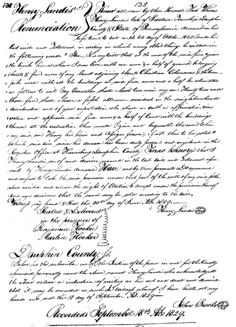
John Niesley and Christian France Administrators of all and singular Goods and Chattles Rights and Credits which were of Michael France late of Paxton Township deceased appeared in Court and produced their account upon the administration of the Estate of the said deceased duly passed before the Register from which there appears to be a balance in their hands of three hundred and seventy five pounds eleven shillings and eleven pence which account upon examination the Court do approve and allow and direct that the said balance after deducting thirteen shillings and two pence the expence of this Court be distributed according to Law

The Court appoint Christian France of Manheim Township in the County of Lancaster Guardian of the person and estate of Mary France a minor daughter under the age of fourteen years of Michael France late of Lower Paxton Township deceased during her minority.

Elizabeth France a minor daughter above the age of fourteen years of Michael France late of Lower Paxton Township deceased comes into Court and chooses Christian France of Manheim Township in the County of Lancaster Guardian of her Estate during her minority and the Court approve of and appoint the said Christian France her Guardian accordingly.

The Court appoint Jacob France of Manor Township in the County of Lancaster Guardian of the persons and estates of John France, Michael France and Veronica France minor children under the age of fourteen of Michael France late of Lower Paxton Township decease during their respective minorities3

I find it quite probable that Christian and Jacob Frantz—guardians of his children—were relatives, perhaps brothers, of Michael Frantz. John Nissley was likely the brother of Michael’s wife Feronica “Franny” (Nissley) Frantz.4

Michael and Feronica (Nissley) Frantz had children:

  1. Elizabeth Frantz (28 Mar 1780—2 May 1850)5 married Rev. John Mumma (11 Mar 1776—3 Aug 1859)6
  2. Mary Frantz (after 17 October 1783—?) 7 married Jacob Snavely
  3. John Frantz (after 17 October 1783—before 1807).
  4. Michael Frantz (22 May 1789—5 Jun 1866) married twice—first to Elizabeth Neidig, daughter of John and Mary (Bear) Neidig, and second to  Elizabeth Walters, daughter of Jacob and Anna (Stauffer) Walters
  5. Veronica Frantz (after 17 October 1783—before 19 May 1810).

Michael Frantz Jr. was the father of Anna Frantz, my 3x great grandmother and wife of Levi Hocker, who died mysteriously in 1876.

A Great Sickness at Harrisburg The Landis Mill Dam Incident

Yellow fever is one of those diseases that was of grave concern to our ancestors. About 1793, Philadelphia was experiencing an outbreak of the disease and when a febrious illness began to manifest in Harrisburg, there was great concern that it had reached them, too.1

Efforts were made to protect the town and its inhabitants—the posting of guards on the roads, turning away travelers, etc. But the general feeling amongst the town’s inhabitants was that the disease was caused by the stagnant waters behind a dam on Paxton Creek. The mill was owned by Peter, John and Abraham Landis.

Articles of agreement were written between John Harris, founder of Harrisburg, and the three Landis men on 16 April 1790. Harris granted them “a mill seat on the waters of Paxton Creek the race whereof to be taken out of the said creek at any place between the two bridges now erected over the same opposite Harrisburgh aforesaid and to be dug or carried through the land of the said John Harris.”2 The men paid £600, plus interest, and were required to provide a sufficient merchant mill within three years.

Then the sickness came.

On 5 May 1794, a meeting was held and a committee designed to meet with the Landis’ and offer them £2500 in exchange for the mill.3 They met with the men the next day. The Landis’ refused to sell.

By January 1795, the inhabitants were determined to take action. At a meeting on 16 January 1795, it was voted to pay the Landis’ £2600 for the mill, and that in case the Landis’ again refused to sell, they would “prostrate the dam erected… and pay our proportionate parts of all legal expenses and damages that may accrue on any suit or suits.”4 An assessment was made on all property in the borough in order to make up the amount of the offer.5 Amongst those assessed for property in town were John, Adam, and Christopher Hocker. A George Hocker—possibly their brother—was assessed as a single man, too.

Apparently, the Landis men were still not willing to sell and instead asked for £2000 for the water-rights alone. The committee apparently believed this was little more than extortion. They refused the counter-offer.

On Saturday, 18 April 1795, the committee and a number of inhabitants went to the dam and with four persons they had hired “opened the creek bed twelve feet wide.”6 This, for all intents and purposes, ruined the dam.

On 29 April 1795, with the dam all but destroyed and no other options, the Landis’ sold the mill property and equipment to a committee comprised of Stacy Potts, Moses Gilmore, William Grayson, Jacob Bucher, John Keen, John Dentzel and Alexander Berryhill.7

 The Landis Family

Peter, John, and Abraham Landis may have been, I believe, brothers and sons of Felix Landis.

Felix Landis of Derry Township died after writing his will on 25 Jan 1770.8 He left his property on Spring Creek to his two sons—Peter and Jacob. Peter, in particular, inherited that piece of the tract “whereupon the house and barn and mill is standing.” This indicates to me that the mill business was a family industry.

All three men were of Derry Township in 1790 when they purchased the water rights from John Harris.9 In 1795 when they sold out, Peter and Eva, his wife, were of Derry Township, John and Catharine, his wife, were of Londonderry Township, and Abraham and Barbara, his wife, were of Paxton Township.10

Friday Find: Henry Landis Renunciation

I’ve been working on the narrative for Martin Hocker (1768-1862) for my A Hacker-Hocker Family recently and I realized that I don’t have much information on his daughter Christianna, born 24 Nov 1808, who married Henry Landis.1

Henry is a common first name in the Landis family; so I’m reviewing documents and trying to piece information together. In my search of Dauphin County deeds, I found the following document.2

Henry Landis Renunciation
In it Henry Landis refused to take the property his father—Henry Landis Sr. of Swatara Township—left to him in his will. A standard enough document. But what caught my eye were the witnesses—Benjamin and Martin Hocker!

Benjamin Hocker was most likely the youngest son of Johan Adam Hocker Jr. of Derry Township. His older brother George—my 4X great grandfather—married Mary Magdalena Landis, daughter of Henry Landis Sr. of Swatara township, on 2 Mar 1819.3

I thought at first that Martin Hocker was likely the son of Martin Hocker Sr. of Derry Township. But then I did the math. Martin Jr. would have been only 17 in 1829. It’s far more likely that he was actually Martin Hocker Sr. If so, then it’s quite possible that this is the Henry Landis who married Christianna Hocker, Martin’s daughter, on 18 Oct 1825.4

While this doesn’t actually prove that this Henry married Christianna Hocker—there’s no mention of her in the deed—it does prove that Henry Landis Jr. was associated with Benjamin Hocker and Martin Hocker by June of 1829.

Jacob Huber’s Martic Township Tract

On 22 November 1717, Martin Kendig (Kendick, Kendrick, Cundigg) and John Herr (Heer) were warranted 5,000 acres in Lancaster County by the Proprietaries of Pennsylvania.1 They, in turn, transferred this land to their fellow immigrants.

Jacob Hoober 1733 land survey

Jacob Hoober 1733 survey

John Taylor surveyed 210 acres from this warrant for Jacob Huber on either 24 or 28th January 1733.2 The survey states: “Under a mistake John Taylor applied for a [Warrant] to the Secretary on the new terms wch was granted as aforesd But Jacob Hoober purchased the right of 210 as of Martin Kendrick  & John Heer part of 5,000 as granted to them & it is accordingly Returned into the Secretary’s office the — day of December 1735.” You can see the warrant here on my site.

Jacob Huber patented this tract of 210 acres on 22 October 1736.3 He had, quite likely, been living on his father, Hans Huber’s property in Earl Township prior to this purchase. He patented several adjoining tracts as well: one directly to the south in 1745 [A3], containing 48 ½ acres,4 and one to the north in 1759 [A1], containing 167 ½ acres.5

Huber/Hoover/Hoober land patents

Huber/Hoover/Hoober land patents

Jacob Hoover left 250 acres [A2 & A3] to his sons Jacob and Mathias. He also left about 150 acres in Contestoga (A1: the tract just north of this one) to his son Christian.6 A distribution from his estate was paid out to his heirs by 14 June 1765.7

Mathias Hoover quitclaimed ½ of the property left to him and his brother to Jacob on 20 November 1772.8  On 21 November 1772, Jacob and his wife Barbara sold 66 acres 40 perches from their piece of the tract to Mathias. By metes and bounds, this piece appears to be the top portion of the tract Jacob Huber patented in 1736, adjoining lands of Henry Huber, the tract willed to Christian Hoover, and Pequea Creek. Mathias took out a mortgage from Marcus Young of Martick on this 66 acres on 4 January 1773.9 Payment was acknowledged on 8 June 1776.

On 12 June 1776, Mathias and his wife Mary sold 10 acres of their land to Henry Resh/Rush.10 On 10 August 1776, Mathias and his wife Mary sold 19 acres from the 66 they’d purchased from Jacob Hoover to John Hart of Conestoga Township.11

I’m not sure about the division of the rest of the property. Jacob Huber Jr. purchased additional land, as did his son, Martin Hoover Sr. However, at least a portion of the land Jacob and Barbara Huber sold to Mathias Huber, eventually found its way back to Jacob’s descendants. In the settling of Jacob Huber’s granddaughter Elizabeth Hoover’s estate, a deed was issued for the sale of her property. This deed stated that the 113 acres being sold was part of the “same premises of which Martin Huber Sen. [her father], died seized testate” which he will to his children equally and that it was “also a part of the same premises which Jacob Hoover & wife by their Deed of Indenture bearing the date the 21st day of Nov A.D. 1772…[granted] unto Mathias Hoover.”12

Hans Boyer’s Conestoga Tract

On 22 November 1717, the Proprietaries of Pennsylvania warranted 5,000 acres to Martin Kendig and John Herr in then Conestoga, Chester County.1  I. Taylor surveyed 210 acres on the Pequea, adjoining Widow Hoober, Ulrich Hoober, and John Ffarrer, part of the 5,000 acres warranted to Martin Kendig and John Heer, to Hans Boyer on 10 May 1719.2 Hans patented this tract on 26 November 1739.3

Hans Boyer Conestoga Tract

Hans Boyer’s Conestoga Tract

Hans Boyer and his wife Barbara sold 210 acres, adjoining John Forrer, Ulrich Huber, and the Widow Hoober, to their son Samuel Boyer on 27 March 1748.4 Samuel Boyer and his wife Mary solid 1 acre to the Mennonist Conegregation on 10 December 1755.5 This became the Byerland Mennonite Meeting house.

On 10 January 1758, Samuel and Mary Boyer sold 14 acres to Tobias Boyer.6 Two years later on 3 October 1760, Tobias and Mary Boyer sold two tracts—including these 14 acres—to David Worley.7 David and his wife Ann then sold these two tracts to Christian Line on 11 March 1769.8

On 10 August 1769, Samuel and Mary Boyer sold 195 acres to Abraham and Mary Hess.9 Several months later, Abraham and Mary Hess sold the 195 acres to Jacob Smith.10 In November 1770, Jacob Smith purchased two tracts of land—including the 14 acres—from Christian and Anna (Boyer) Line.11

Jacob and Magdalena (Good) Smith sold two tracts—ten acres 126 perches and one acres 58 perches—to Abraham Kagey on 22 June 1776.12 The couple sold 60 acres to John Funk.13 On 15 October 1780, John and Ann Funk confirmed these same 60 acres back to Jacob Smith.14 Then on 20 December 1784 Abraham Kagey’s executors—Abraham Kagey Jr. and Christian Shank—sold the two tracks totaling about 11 acres purchased from Jacob Smith to Andrew Sureus.15 Andrew & Catherine Surearus sold on 13 September 1790 two tracts to Christian and Peter Huber—one of 10 acres 126 perches and the other one acres and 58 perches.16

After Jacob Smith’s death, the 195 acres he owned were partitioned into two sections. The first, containing 125 acres 50 perches was granted to Jacob Smith [Jr.]. The other contained 72 acres 78 perches (not including the acre deeded to the Mennonists) and was granted to Christian Smith. Jacob Smith renounced his claim to the 125 acres, so it was awarded to Abraham Smith, the third son. However, Abraham then sold this parcel to Jacob on 11 April 1805.17 Then in May 1805, Jacob Smith sold to his brother Christian two tracts from the 125 acres—one of 40 acres 150 perches, adjoining land of Jacob Smith, Abraham Huber, Henry Zercher and Christian Smith, the other of three acres 140 perches, adjoining land of Jacob Smith, Christian Smith and Pequea Creek.18


John Jacob Goughnour’s Conestoga Tract

On 24 Jan 1733, John Goughnour warranted 105 acres on a branch of the Pequea in Conestoga (now Pequea) Township, Lancaster County, Pennsylvania, recorded in Lancaster County Warrants #G14. Three days later, John Taylor surveyed the property, noting it adjoined Christian Preaaman [sic], Have Line [sic], Christian Stone, and Samuel Buyer.1

John Jacob Goughnour's Conestoga tract survey

John Jacob Goughnour’s Conestoga tract survey

On 15 April 1761, Jacob Gouchnour patented these 105 acres.2 Jacob purchased another 167.5 acres in Conestoga from Christian Hoober on 26 Nov 1761.3 [see “Christian Preaaman” on map] This tract had been warranted to John Smith in 1734 and patented to Jacob Huber in 1759.

Jacob Goughnour had died prior to 4 Nov 1780 when his heirs—Jacob & Margaret Goughnour, Christian Goughnour, Henry & Ann Goughnour, Abraham Goughnour, Tobias Goughnour, Christian & Catharine (Goughnour) Hess, and Joseph Goughnour—sold 50 acres of this tract, adjoining Samuel Byer, to his son John Goughnour.4

On 12 Mar 1781,  John & Elizabeth Gochenour sold this 50 acres, adjoining Samuel Buyers, to his brother Adam Gochenour & Henry Rush, all of Conestoga Township.5 Adam and the Rushs held onto the property for a little over a year before selling it to Christopher Ort on 23 Aug 1782.6

Christopher Ort, a mason, and Catharine his wife sold this 50 acres to Daniel Musser of Strasburg Township on 21 Nov 1795.7

Jacob Boyer’s Conestoga/Martic Tract

On 22 November 1717, Martin Kendig (Kendick, Kendrick, Cundigg) and John Herr (Heer) were warranted 5,000 acres in Lancaster County by the Proprietaries of Pennsylvania. They, in turn, transferred this land to their fellow immigrants. On the 12th of 9mo (November) 1720, four tracts on the Pequea were surveyed in the right of Martin Kendig and Hans Heer to Hans Boyer, Jacob Hoober, Martin Boyer/Abraham Smith, and Christian Stone/Jacob Boyer.1

Jacob Boyer's Conestoga tract

Jacob Boyer’s Conestoga/Martic tract

Sometime between 1720 and 1735, the land was passed from Christian Stone to Jacob Boyer. “Jacob Biers” patented 162 acres on Pequea Creek on 1 Oct 1735.2 Jacob Boyer apparently lived on this tract for his entire life.

On 20 Jun 1772, Jacob (the elder) and his wife Catharine sold 112 acres from their two tracts—they owned another tract adjoining the first directly to the south in Martic Township—to their son Henry Boyer.3 This piece of property adjoined that of Jacob Boyer Jr., John Jameson, and Samuel Boyer, and lay along the eastern edge of Jacob Sr.’s two tracts.

On the same date, Jacob and Catharine also sold 160 acres from their two tracts to Jacob Boyer Jr. This piece of land included all the land north of Pequea Creek and a strip south of the creek between those of Henry Boyer (to the east) and one previously sold to Abraham Smith (to the west).4

Jacob was apparently preparing for the future in Jun 1772. He also wrote his will at that time. The will abstract names his wife Catharine, children: Jacob, Henry, Barbara, Anna, Mary, Catharine and Elizabeth wife of Jacob Steiner, and grandchildren: Cornelius and Frederick Steiner. The will was probated 30 Oct 1775 and named Catharine and son-in-law Jacob Steiner as executors.5

Several years later, on 22 Oct 1781, Jacob [Jr.] and Mary Boyer sold 16 acres from their tract to Rudy Miller.6 By metes and bounds this piece was situated in the northwest corner of the plot, north of Pequea Creek. It adjoined land of Rudy Miller, John Line and Pequea Creek.

On 3 Mar 1806, Rudy Miller’s heirs—Rudolph Miller, Stephen & Mary (Miller) Rine, and Hugh & Barbara (Miller) Evans—sold their interest in Rudy Miller’s four tracts of contiguous land in Conestoga and Martic townships, including this 16 acres, to John Miller, another of Rudy Miller’s children.7

Ulrich Huber’s Conestoga Tract

Last week’s article for the “Along the Pequea” series, traced the land transactions of Hans Line’s property. This week, we’ll follow the transactions of his neighbor, Ulrich Huber.

Ulrich Huber first appears in Conestoga in the 1728 survey of his Conestoga plantation (see figure 1).1 John Taylor surveyed 226 acres, adjoining John Line, John Dehoof, and Jacob Hoober.  However, we can presume he was in Pennsylvania by 1718. He was naturalized with a large group of Mennonite settlers in 1729 who had “transported themselves and estates into the province of Pennsylvania between the years one thousand seven hundred and one thousand seven hundred eighteen.” 2

Woolrich Hoober survey

Figure 1: Woolrich Hoober 1728 survey

Ulrich received a warrant for this property 19 Sep 1744.3 He patented the tract either 19 or 20 Sep 1744.4 He was taxed for property in Conestoga in 1751 and 1754.5

On 16 Nov 1750, Ulrich sold 15 acres to his neighbor Michael Hess.6 On 7 Dec 1754, Michael and Barbara Hess sold their 15 acres from Ulrich to Michael Harnis[h].7 I found no subsequent deed of sale from Michael Harnish for this 15 acres. However, when Ulrich’s tract was sold to John & Henry Brenneman in 1791, it included the entirety of the tract patented to Ulrich Huber.

Ulrich died prior to 18 May 1757.8 On 23 Jun 1759, his heirs—Jacob & Barbara Hover, Henry & Anna [Hover] Shank, Jacob & Maria [Hover] Boyer, Elizabeth Hover, Ulrick Hover and Henry Hover—transferred the land to the eldest son John Hover, witnesses were [Christian?] Line and Michael Shank.9

John and Mary, his wife, held on to this property for nearly a decade before selling it to Melchor and Ann (Good) Brenneman on 10 Oct 1767.10 The Brenneman’s held onto the land until 1783 when they sold it to their daughter and son-in-law John and Eve Bowman on 22 Mar.11 Eight years later, John and Eve (Brenneman) Bowman sold the property to her brothers John and Henry Brenneman.12

John and Henry apparently partitioned the property. John and Catharine Brenneman sold their 113 acres, adjoining Jacob Smith, John Good, George Rathvon, Christian Line, and Abraham Huber, to Henry Zercher on 7 May 1794.13 Zercher later died intestate and John Brenneman bought back the property on 10 May 1806 when Zercher’s heirs refused the land at it’s appraised price.14 John and Catharine then sold the tract to Jacob Heidelbach on 12 May 1806.15

5,000 Acres—Where Did It All Go?

The earliest established settlement in Lancaster County occurred in the fall of 1710 while it was still a part of Chester County. A small group of Mennonites made a deal for land with William Penn. He wrote to the Ambassador in the Netherlands in April 1710 telling him of a party coming to Holland in order to go to Pennsylvania.1

We know their names because this group wrote a letter to the Mennonite leaders in Amsterdam dated 27 June 1710 to thank them for their assistance. They were on their way to Pennsylvania, expecting to sail within a few days to Gravesend, England and from there to America.2 The letter was signed by Martin Oberholtzer, Martin Kendig, Christian Herr, Jacob Müller, Martin Meili, and Hans Herr. Their ship, the Maria Hope, arrived in Philadelphia 23 September 1710.

On 8 October 1710 land warrants were issued to Martin Kundig, Martin Meily, Christian Herr, John Herr, Wendell Bowman, John Bundely, Christopher Franciscus, and Jacob Müller.3 Martin Oberholtzer, an original member of the group, did not participate in the land purchase. Surveyor James Taylor was ordered on 10 October 1710 to survey 10,000 acres for the Colony of “Swissers lately arrived in this Province” at Pequea.4 The area they settled includes present day Willow Street, stretching across West Lampeter Township over Pequea Creek and into Strasburg Township and Strasburg village. The purchase was divided amongst these men on 12 April 1711.5

Original Lancaster Warrants

Original Pequea Settlement Land Warrants

About 1715 or 1716, Martin Kendig returned to Europe to convince other Mennonite families to come to Pennsylvania. On 22 November 1717, Martin Kendig & Co. (John Herr) were issued a warrant for 5,000 acres in Chester County (now part of Lancaster County).6 I found the following in the Copied Survey Books:

Pensilvania SS
(Seal) By the Commissioners of Property
At the Requests of Martin Kundigg and Hans Heer both of the Township of Strasburg in this Province that we would Grant them to take up Several Tracts among the late Surveys made on Conestoga and Paque Creek the quantity of ffive Thousand Acres of Land for which they agree to pay to the Proprietrs use ffive hundred pounds Mony of the said Province for the whole or in Proportion should there be Returnd upon the Survey thereof more or less and the Yearly quitrent of one Shilling Sterling for every hundred Acres These are to Authorize and Require thee to Survey or cause to be Survey’d unto the said Martin Kundigg and Hans Herr among the said late surveys according to the Method of Townships appointed in several Regular Tracts the quantity of ffive Thousand Acres of Land that hath not been already Survey’d nor appropriated nor is Seated by ye Indians and make Returns thereof into the Secretarys Office which surveys by thee mad by Vertue hereof in case the said Martin & Hans fulfill the above agreement by paying down the said sum of Mony upon the Returns of the said surveyes shall be Valid otherwise the same is to be Void as if it had never been made of this Warrant ever granted Given under our hands and Seal of the Province at Philada the 22d day of 9br [November] Anno Din 1717

Richard Hill

Isaac Norris

James Logan

To Jacob Taylor Surveyr General

In Testimony that the above is a copy of the original remaining on file in the Department of Internal Affairs of Pennsylvania made conformably to an Act of Assembly approved the 16th day of February 1833, I have hereunto set my Hand and caused the Seal of said Department to be affixed at Harrisburg, this Thirtieth day of March 1909

Henry Hauck

Secretary of Internal Affairs7

The Chester County Old Rights Index notes a number of surveys associated with this warrant. They include:

  • D78:3—10 Nov 1720, Joyst Lette, 190 acres on west side of Conestoga, adjoining Toris Ebys, Henry Funk, London Company Tract, and William Huse
  • D78:4—28 8br [October] 1728, Hans Line, 200 acres on a branch of Pequea Creek, adjoining Martin Boyer (now Abraham Smith), Christian Stone (now Jacob Boyer), and Christian Prenaman
  • D78:5—12 Oct 1731, John Long, 473 acres (325 by right of Martin Kendrick & John Heer), adjoining Jacob Stoner, Poston Fink, Abraham Miller, James Thornbury, Peter Lane and Henry Lane
  • D78:37—12 9br [November] 1727, Abraham Burkholder, 250 acres, and Benjamin Wittmer, 150 acres; Benjamin Wittmer sold to Henry Bear, returned 26 Oct 1734
  • D78:38—20 9br [November] 1727, Martin Kendrick, 50 acres on a branch of the Pequea, adjoining John Hess, Joseph Steeman, and Martin Kendrick
  • D78:271—29 May 1718, John Snevely (son of John Jacob Snevely), 200 acres; Peter Yortee (now John Jacob Snevely), 200 acres; Jacob Funk, 200 acres; all three tracts northwest of Conestoga Creek
  • D78:2722[4?] November 1717—John Snevely, Jacob Snevely, 137 acres, adjoining Robert Eares, Tho. Thornbury, John & Jacob Snevely; returned 3 Jun 1735
  • D78:273—2[4?] 9br [November] 1717, John Snevely & Jacob Snevely, 76 acres, adjoining other land of John & Jacob Snevely
  • D78:274—John Snevely, returned 3 Jun 1735
  • D78:275—24 9br [November] 1717, John Funk, 100 acres on a branch of the Conestoga, adjoining Jacob Funk
  • D78:282—13 January 1745/6, Michael Miller, 269 acres in Hempfield township, adjoining Jno Knisley, Felix Miller, Hans Adam Libhart, Wido Hipkin
  • D78:293—2 June 1718, Henry Muscleman, 200 acres on a small branch of the Little Conestoga, adjoining land of Michael Costman’s children
  • D78:294—30 May 1718, Roody Moyer, 200 acres on a branch of the Conestoga, adjoining John Funk
  • D71:42—3 9br [November] 1729, Michael Graff, 100 acres on a branch of Beaver Creek, adjoining Jacob Graff, Isaac Herr, and Michael Graff
  • D71:51—3 9br [November] 1729, Michael Graff, 125 acres, adjoining Michael Graff and Jacob Prowprather
  • B22:45—31 May 1718, Martin Kundigg and John Heer, 200 acres on a branch of the Little Conestoga, granted to John Witmore, adjoining Andreas Coffman, Christian Peelman and Henry Pare
  • D82:1—20 June 1719, Jacob Bheam, 57 acres on a branch of the Pequea; 9 9br 1720, Hans Hess, 125 acres, adjoining Jacob Bheam
  • D82:2—25 8br[October] 1726, Hans Hoober, 50 acres [Earl Township], adjoining Hans Hoober and Hans Muscleman
  • D82:3—23 June 1721, 3 tracts of 150 acres each for Hans Moyer, Hans Musleman (+50 acres), Hans Hoober (+50 acres), situate between Mill Creek & the Conestoga
  • D82:16—18 8br 1728, Hans Hess, 195 acres, adjoining Philip Rudesille, Martin Kendrick, John Jacob Moyer, John Dehoof, Hans Hess and Christian Stoner
  • D82:18—20 8br 1730, Hans Hess (see previous survey)
  • D82:19—20 May 1719, Barbara, widow of Jacob Hoober, 102 (corrected to 105) acres, adjoining Hans Boyer, John Line and Martin Boyer
  • D82:24—19 Mar 1747/8, Isaac Heer (father of Hans Heer), 260 acres (312 on resurvey in 1757), adjoining land formerly of Amos Strettle (Peter Musser and Christian Shoults), formerly of John Taylor (Jacob Beam, William Stewart, Martin Bear), Jacob Prowprather, Adam Thomas, and Henry Hoover
  • D82:33—21 9br 1719, Jacob Graff, 400 acres on a branch of Beaver Creek, adjoining Thos. Smith, Michael Graff, Isaac Herr, and John Koyle
  • D82:40—10 8br 1827, to John Bowman, father of John Bowman, 150 (corrected to 147) acres on a branch of Beaver Creek, adjoining Amos Strettle and Caspar Bowman, a warrant to accept this survey was dated 1 9br 1744
  • D82:41—Hans Graff, 1419 acres +91 acres from later survey returned on 13 October 1742
  • D82:47—22 June 1721, two tracts for Henry Bear, 200 acres (now his son Jacob Bear) and Martin Graff, 151 acres, between Mill Creek and the Conestoga
  • D82:51—10 8br 1727, Hans Graff, 1419 acres in Earl Township, 250 acres of which is part of the Kendig/Heer warrant, the rest from a warrant to Hans Graff on 4 8br1718 for 1150 acres, tract adjoining Christian Winger, Hans Brady Negly, Conrade Roode, Adam Painter, Philip Shiesfer, Peter Goode, and Henry Bear
  • D88:127—20 October 1728, Woolrick Hoober, 226 acres on a branch of the Pequea, adjoining John Dehoof, Jacob Hoober, and John Line
  • D88:130—16 8br 1730, Jacob Hess, 200 acres on a branch of the Conestoga, adjoining Jacob Bear and John Ulrick Hoober
  • D88:133—12 May 1731, Andrew Hershey, 424 acres (300 acres in right of Martin Kendig & John Heer) on a branch of the Shickasalungo Creek
  • D88:134—20 June 1719 and 10 October 1731, Jacob Behme, 381 acres total (including 57 from previous survey) on a branch of Pequea Creek, adjoining Hans Hess, Robert Creage, Christian Prenaman, Henry Hoober, Christian Heer
  • D88:135—28 January 1733, Jacob Hoober, 210 acres on the Pequea, adjoining Jacob Good and Samuel Buyer
  • D88:136—30 May 1718, Toris Ebys, 300 acres on Conestoga Creek, adjoining lands of Henry Funk and Michael Shank
  • D88:137—30 May 1718, Toris Ebys, 300 acres on Conestoga Creek, adjoining Henry Funk and Michael Shank
  • D88:138—10 May 1719, Hans Boyer, 210 acres on Pequea Creek, adjoining Widow Hoober, Ulrich Hoober, and John Farrer
  • D88:139—20 8br 1729, Samuel Boyer, 115 acres on Pequea Creek, adjoining John Goughnower, Christian Stone and Jacob Hoober
  • D88:140—12 9br 1720, 4 tracts on Pequea Creek surveyed for Hans Boyer (88 acres), Jacob Hoober (81 acres), Martin Boyer now Abraham Smith (84 acres), Christian Stone now Jacob Boyer (164 acres)

I don’t know if these add up to 5,000 acres—some of the surveys are duplicates or overlap previous surveys; some include land from separate warrants. But they should be a good representation of the Kendig & Herr 5,000 acre warrant as divided amongst Lancaster settlers after November 1717.

If you’re searching for information on early immigrant ancestors who settled in Lancaster County, you can find land information at the website of the Pennsylvania State Archives. The warrant registers for Lancaster County will list warrants issued starting in 1733. For earlier records, try the Old Rights Registers for Philadelphia, Bucks and Chester counties—Chester is the best place to start for pre-1729 Lancaster records.

If you know who the land was patented to, but not who it was warranted to, try the Patent Indexes. That will give you the warrantee and warrant date. The warrantee township maps are also a good place to look if you’d like to see where your ancestor’s property was located. The files are listed by the modern townships, so you’ll need to know the relationship between the historical townships and the modern ones. If you don’t, try this map at the Lancaster Historical Society’s website.

Lancaster deeds for this period are also available online. You can read more on how to use the online reader and where to find images from the Grantors index. Unfortunately, the Grantees indexes are not online, so you may have to get creative to find what you’re looking for. Deeds and deed indexes are available through the Lancaster County Recorder of Deeds and FamilySearch.

Have you found a Lancaster County ancestor in online records? What did you learn about them?